
GGS researcher envisions future NASA satellite capabilities
Almost every aspect of the Earth system, including land, water, ice and atmosphere, is currently being measured by sensors on satellites. Konrad Wessels, Associate Professor, Geography and Geoinformation Science, says we are experiencing the “Golden Age of Earth Observation” with increasing numbers of highly advanced satellites being launched every month. As a result, NASA initiated an “Incubation” program aimed at identifying gaps in required observations and satellite technology, as well as ways these gaps could be addressed over the next ten years. These efforts will ultimately aid in understanding global change and help model and predict how environmental changes may impact humans.
The study, “Observing Earth’s Changing Surface Topography & Vegetation Structure,” analyzed questions involving Surface Topography and Vegetation structure (STV), addressing the need for global, high resolution and frequent vertical measurements of bare-surface land topography, ice topography, vegetation structure, surface hydrology and shallow water bathymetry. Wessels was awarded a NASA grant to participate in the study, specifically to look at measuring vegetation structure.
“It was a privilege to work with a large team of world- renowned NASA experts, although it was very demanding to coordinate the study and complete the report remotely during COVID,” said Wessels. “It provided me a rare vantage point to foresee the earth observation developments that may occur over the next ten to 20 years.”
The measurement of vegetation structure allows scientists to estimate the biomass and hence the carbon stocks of forest, along with their capacity to sequester more carbon from the atmosphere at global scales. Additionally, to monitor how human activities (e.g. deforestation or selective logging) and climate change alter 3D forest habitat with potential impacts in biodiversity. Wessels’s research has long focused on using remote sensing to measure vegetation structure. He focuses heavily on Savannas, specifically in his native South Africa, which are highly dynamic due to the impacts of wildfires, fuelwood removal, shrub encroachment, climate change and elephants.
Why does such data matter? According to Wessels “you need a way of monitoring and mapping vegetation change for decision making and active management interventions.” For example, in Namibia, Wessels said authorities are now planning to use biomass fueled power stations that utilize local shrubbery for electricity as these shrubberies negatively affect wildlife tourism and the capacity for livestock. Others, like the South African National Parks, use this satellite-derived data to determine the long-term impact of fire management strategies and elephant densities on trees and shrubs structure across entire national parks.
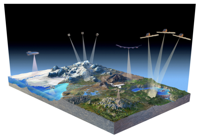
Additionally, high-resolution characterization of surface topography would allow for improved understanding of geologic structure, tectonic and volcanic activity, geomorphic processes, sea-level rise and storm surge in coastal areas, glacier and ice sheet mass balance and flow characteristics, and other dynamic processes that could provide new insights into forecasting of natural hazards. In a similar manner, high-resolution characterization of vegetation structure could lead to significant improvement in the understanding of ecosystems, including carbon stocks and fluxes, the relationships between biodiversity and habitat, as well as the role of forest structure as the fuel in disastrous wildfires.
Wessels is also working on another NASA-funded research project that focuses on satellite measurements of changes in trees and shrubs in Savannas. Along with Mason PhD student Xiaoxuan Li, and partners at University of Maryland, the research team uses a Lidar sensor called “GEDI” (short for Global Ecosystem Dynamics Investigation) mounted on the International Space Station to monitor woody vegetation structure in African and global Savannas. The GEDI sensor is a “Ventures” class NASA mission used to test innovative technology and demonstrate its scientific value, in line with other STV Incubation activities that may lead to a dedicated vegetation Lidar satellite mission in future.
“I hope to bring these insights into my remote sensing classes and continue to involve students in on-going research, Wessels said.